Study provides a step-change in our understanding of New Zealand’s groundwater
Earth Sciences New Zealand has developed a world-first National Groundwater Age Map and a powerful suite of tools to support the sustainable management of our hidden groundwater resources, from national through to local scales.
28 November 2025
The six-year Te Whakaheke o Te Wai research programme has combined innovative techniques in environmental tracers and modelling, with mātauranga Māori, to reveal new insights about the age, source, flow and cultural values of the water in Aotearoa New Zealand’s underground aquifers.
Groundwater is critical for New Zealand’s freshwater security, providing 40% of our drinking water, and more than 80% of the water flowing through our rivers, streams and wetlands. It’s also a vital resource for our primary sector, with groundwater irrigation estimated to contribute more than $2 billion to New Zealand’s economy annually.
Groundwater age information can help identify where groundwater may be susceptible to contamination and holds insights to evaluate the sustainability of groundwater extraction and guide water management. Earth Sciences New Zealand developed the innovative National Groundwater Age Map from more than 1000 groundwater samples to provide an overview of groundwater age and groundwater/surface water interaction across the country.
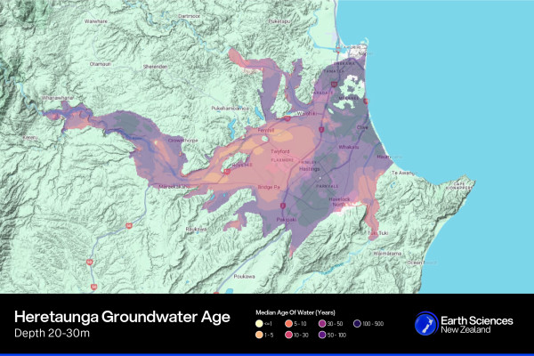
The age of groundwater at different depths in aquifers around the country can be explored through the National Groundwater Age Map
Groundwater age offers insights to manage potential contamination
Researchers found the groundwater supplying most of the wells was between one and 100 years old, however some deep wells in Taranaki and the Marlborough regions held water that was 40,000 years old. At the other extreme, Wairau had the youngest groundwater: water there took only two weeks to move through the aquifer system.
Younger systems can be vulnerable to contamination from live pathogens and nitrate loads, whereas older water presents a challenge with nitrate contamination potentially taking decades to work its way through the aquifer. The research offers practical insights for public health.
“Knowledge of water age and flow rates is important for managing potential contamination of drinking water. We’ve created a drinking water protection zone guideline to help protect wells from pathogens in the fast-flowing groundwater found in some of our aquifer systems, such as the Heretaunga Plains,” says Programme co-lead and Principal Scientist Dr Uwe Morgenstern.
The programme has also developed a National Groundwater Model to inform water management decisions. The national model incorporates data such as geology and soil characteristics, climate, surface water hydrology, groundwater levels, and groundwater age. It is available as an interactive map, integrating “Rapid Model Build” tools that can zoom in from national to regional to local scales. These numerical models can be used to test different scenarios.
“These tools allow decision-makers to build models more cost-effectively, so that they can answer environmental management questions more quickly, wherever they are needed.”
Programme co-lead and Principal Scientist Dr Catherine Moore
Using modelling to address community concerns about the Paritua Stream at Bridge Pā
As part of wider work in the Heretaunga Plains, the team built a local-scale model to help address community concerns about the Paritua/Karewarewa Stream at Bridge Pā, a culturally significant stream running alongside two marae.
Mana whenua have observed declining water levels in the stream in recent years, although a long continuous record at Bridge Pā is still needed to quantify the detail of these trends. It ran dry in 2021 and again in early November 2025. When this happens, it makes it harder for mana whenua to collect mahinga kai.
“We lost a lot of our kokopu. Eels were stuck in holes. If you look at it in Māori eyes, our river is calling for help,” said Robert Turner, Bridge Pā spokesperson, about the 2021 event.
These low flow impacts occur in the sections of the Paritua/Karewarewa which naturally lose flow through the stream bed.
The Te Whakaheke o Te Wai team worked with Ngāti Kahungunu ki Heretaunga to incorporate mātauranga Māori into the models, which provided insights extending into the past beyond those we have from modern instrumental records. Historical evidence was also included, such as maps of past swampy areas and wetlands, the changing local land levels following the 1931 Napier earthquake, and changes following European settlement such as land clearances, gravel extraction, surface water diversions and irrigation. Together with Western science data (e.g. measurements of groundwater levels in wells, groundwater age tracer information, rainfall estimates), this has resulted in a powerful tool for exploring future stream restoration and water management options.
“We’ve essentially compiled a ‘biography’ of the Paritua Stream catchment, capturing the natural and artificial changes that have occurred over time. This allows us to design the model to answer specific questions raised by the community, such as “What did the stream used to be like in pre-European times?” and “What methods would restore the stream flow?” says Moore.
“The model gives a numerical voice to the community, empowering them to trust and contribute to the conversation about the management of the stream’s catchment.”
The models indicate the strongest influence on Paritua stream flow is rainfall, so even in pre-European times, during very dry periods, the stream would have likely ran dry at Bridge Pā. During the 1970s - 1990s the Paritua stream catchment was augmented by channelled surface irrigation (‘border dyke irrigation’) water sourced from the Ngaruroro River, which served to keep the stream flowing even during dry periods. The team explored the potential impacts of switching off well pumping in the catchment during a dry year, but found that while it would provide some relief, it would not prevent the stream from running dry.
Other restoration options identified as more likely to be effective were sealing the stream bed in those sections with highly permeable gravel, and bringing water into the catchment: either directly into the stream, or indirectly to feed a wetland.
While bringing water into the catchment directly or via wetlands can sustain flow during dry periods, the research also shows that long-term restoration will require attention to the chemical compatibility between source water and the stream bed. If the water added into the system is low in minerals, it may gradually dissolve the natural tufa (carbonate deposit) sealing in parts of the Paritua, increasing water loss through the stream bed over time.
The Bridge Pā model was part of a wider case study of the Heretaunga Plains, developed in partnership with Ngāti Kahungunu and Hawke’s Bay Regional Council.
“One of the things that has been missing for mana whenua in the past is the imbuing of our mātauranga into the models and tools that are used to manage water. Te Whakaheke o Te Wai has provided an opportunity for Ngāti Kahungunu to step in alongside of this process and reframe our focus and direction for water management going forward.”
Marei Apatu, Senior Executive Manager Te Kaihautū, Te Taiwhenua o Heretaunga, Ngāti Kahungunu
Hawke’s Bay Regional Council Team Leader - Hydrology and Groundwater Science Simon Harper says that Te Whakaheke o Te Wai’s research has supported the council’s efforts to ensure sustainable management of the groundwater of the region.
“We’ve been incredibly fortunate as a community to have Earth Sciences New Zealand experts invest significant time and resources - at no direct cost to the rate payer - to provide independent analysis that’s helping us navigate a complex and often contested issue,” says Hawke’s Bay Regional Councillor Di Roadley.
To calculate the groundwater age, researchers used an innovative tracer technique to identify where the groundwater has come from and how long it has been underground. One of the tracers used is Tritium, a radioactive isotope of hydrogen produced in the atmosphere by nuclear reactions between cosmic rays and atmospheric gases. After Tritium combines with oxygen forming water molecules, it becomes part of the water cycle. As part of the rainwater, it enters groundwater systems and there it can be used as a 'radioactive clock'. When the rainwater infiltrates into the ground and becomes separated from the atmosphere, the clock starts to tick, with the Tritium concentration decreasing. This decrease can be measured and the age of the groundwater calculated.
Te Whakaheke o Te Wai was funded by the Ministry of Business, Innovation & Employment (MBIE) Endeavour Fund. PHF Science, Hawke’s Bay Regional Council, Environment Canterbury, Monash University, University of Saskatchewan, Luxemborg Institute of Science and Technology, Hastings District Council, Hawke’s Bay District Health Board, Ministry for the Environment and Ngāti Kahungunu are co-funders.
Researchers will use the models developed by Te Whakaheke o Te Wai to forecast climate change impacts on water availability and associated land use changes on water quality, through Earth Sciences New Zealand’s new Future-Proofing Groundwater Systems programme.