
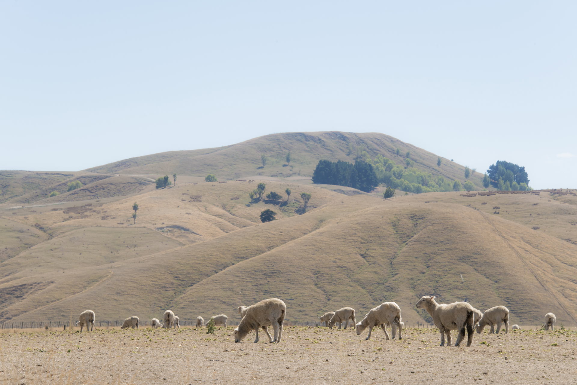
El Niño is a global phenomenon, originating with the warming of ocean temperatures in the eastern and central equatorial Pacific. Historically this has resulted in a New Zealand spring dominated by westerly quarter winds (southwest to northwest), typically bringing drier than usual conditions for eastern and northern areas of both islands and wetter than usual conditions for the western and lower South Island.
“Observations of sea surface temperatures in the east-central tropical Pacific show the hallmarks of a historically strong event, which is also echoed by the modelling,” says Chris Brandolino, Earth Sciences New Zealand Chief Scientist Weather and Seasonal Forecasting.
A sea surface temperature (SST) difference from average, known as an ‘anomaly’, of 1.5°C is a marker of a ‘strong’ El Niño; if the anomaly reaches at least 2.0°C that’s considered very strong, sometimes termed a ‘super’ El Niño. The top five strongest El Niño events (1972, 1982, 1991, 1997, 2015) all had SST anomalies near or slightly above 2.5°C. The SST anomaly recorded for this event has already exceeded 1.0°C and will continue to increase.
“At the very least we’re expecting this event to rival the intensity of these historical top five events, but it has considerable potential to exceed them all.”
Chris Brandolino, Chief Scientist Weather and Seasonal Forecasting
Likely impacts on New Zealand’s weather this spring
Earth Sciences New Zealand and MetService meteorologist Jon Tunster says it is important to recognise that New Zealand’s weather is influenced by many factors. These include the Indian Ocean Dipole (shifting ocean temperatures in the Indian Ocean), regional SSTs, occasional influences from Antarctica, and climate change.
“There’s more to it than El Niño, or even Super El Niño, but this El Niño event is shaping up to have a major influence, potentially from September onwards.”
“As we’ve seen with the previous El Niño events, the overwhelming majority of long-range models are favouring drier than usual conditions for northern and eastern areas of New Zealand, while western regions – especially of the South Island – are likely to see increased rainfall.”
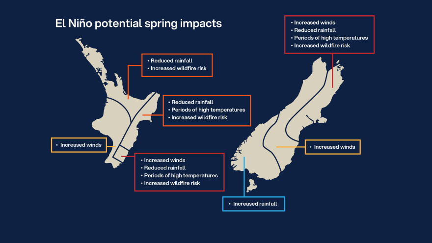
“The combination of wind and reduced rainfall will dry soils, and lead to periods of increased wildfire danger – especially when temperatures are elevated and humidity is low. These conditions are most likely to occur on the eastern, and perhaps northern, sides of the country,” says Tunster.
“The prospect of lower rainfall in several regions is likely to result in reduced groundwater recharge, creating challenges for water-reliant sectors.”
What to expect over the next three months
Weather patterns ahead of spring are likely to be mixed. For example, a significant rain event is expected within the first 10 days of July, likely affecting eastern areas of both islands. However, over the longer-term, these same areas are expected to see a decrease in rainfall as westerly winds begin to dominate.
The Earth Sciences New Zealand Seasonal Climate Outlook for July to September forecasts:
- An eventual lean towards drier than usual conditions for Canterbury, Marlborough, eastern Otago, Wairarapa, and from Hawke’s Bay to Gisborne.
- Drier than normal conditions for Taranaki to Bay of Plenty through to Auckland and Northland.
- Wetter than usual conditions for Westland through to Southland, perhaps extending into parts of Central Otago.
- Windier than usual conditions for much of the country from late winter into spring.
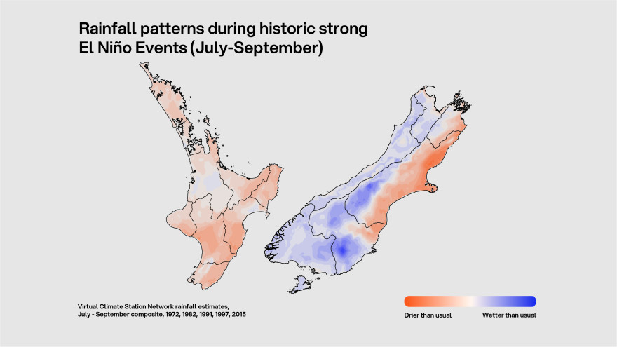
Patterns and variation in how past El Niño events have played out.
Comparison of the top five historical El Niño events clearly indicates the recurring pattern of an unusually dry spring in the north and east, and wetter in the south and west. These dry conditions were particularly pronounced in parts of Canterbury in all five events, with only two thirds of normal rainfall for the period of July to September.
“It’s important to bear in mind that while we know the average outcome of El Niño because of historical data, no El Niño is average—each comes with a unique set of climate characteristics and therefore can be expected to influence the weather differently,” says Brandolino.
Subtle differences in wind direction can affect temperature and strongly inform rainfall patterns, and there are examples of notable variation across the five historical events.
“In 2015, springtime weather patterns favoured an increase in southwesterly and southerly flows, whereas 1972 saw more high-pressure systems near the North Island, bringing increased northwesterlies across the South Island. As a result, spring of 2015 was almost a full degree cooler than 1972, which is especially notable given that the background climate has warmed over that same period,” says Tunster.
The impact of small differences in wind direction is also evident when comparing summer rainfall from 1972/73 with 1997/98.
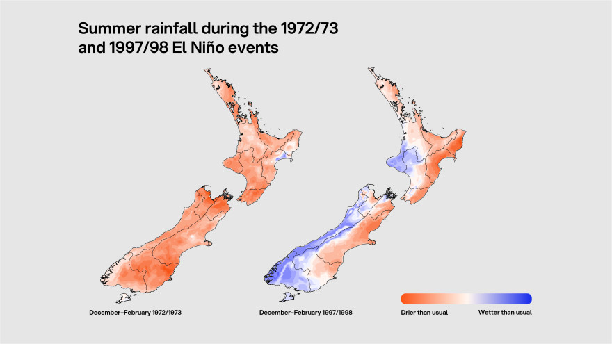
“We saw nationwide dryness in the earlier event, and more regionally confined dryness in the latter,” says Tunster.
Strong El Niño events can influence weather patterns across multiple seasons. Earth Sciences New Zealand will continue to provide further updates through our monthly Seasonal Climate Outlook as this event develops.